Pictured Rocks National Lakeshore is full of gorgeous views and there’s loads of great hikes that you can do. My favorite of these is the Chapel Mosquito Loop which takes you through the forest to a waterfall before continuing on along the gorgeous cliffs of Lake Superior. You’ll visit one more waterfall before returning to the trailhead.
This loop is over eleven miles, so it’s not a short, easy trail. However, it’s my favorite trail at Pictured Rocks National Lakeshore and it’s a fantastic way to spend a few hours.
This guide will have everything you need to plan your hike.
Should You Hike Clockwise or Counter Clockwise?
As the name suggests, the Chapel Mosquito Loop is a loop. Therefore, you’ll need to decide if you want to hike clockwise or counterclockwise.
If you hike clockwise, you’ll visit Mosquito Falls before hitting Mosquito Beach. Then you’ll hike east along the cliffs before reaching the highlight of Chapel Rock. From there, you’ll head back into the forest with a stop at Chapel Falls before returning to the trailhead. Counterclockwise will obviously take you the reverse of this.
Fundamentally, I don’t think it makes too big of a difference which direction you choose to hike. I intended to hike clockwise because what I read about this trail seemed to indicate that it was slightly better if you hike this direction.
I say I intended to hike clockwise, but, right off the bat, I took a wrong turn and ended up hiking counterclockwise. I don’t think it made much off a difference but I do agree that Chapel Falls is more impressive than Mosquito Falls. So if you hike clockwise, you’ll save the best for last.
The other thing I have to mention is that I found the trail from the trailhead to Chapel Falls easier than the section from Mosquito Falls to the trailhead. I’ll cover these sections more in depth later in this post, but another positive for hiking clockwise is that the end of your 11 mile hike may feel easier.
All that said though, it’s possible to hike the Chapel Mosquito Loop in either direction, but given the choice, I’d pick clockwise.
Hiking the Chapel Mosquito Loop
Now that the logistics are out of the way, let’s talk about the Chapel Mosquito Loop hike itself. I’ve laid this out in a clockwise direction (despite the fact that I hiked counterclockwise). If you choose to hike counterclockwise, your experience will just be the reverse of this.
Trailhead to Mosquito Falls
From the trailhead, you’ll immediately want to head left. If you start hiking straight, you’ll end up hiking in the trail in a counterclockwise direction. So if you’re adamant about hiking clockwise, take the trail to your left.
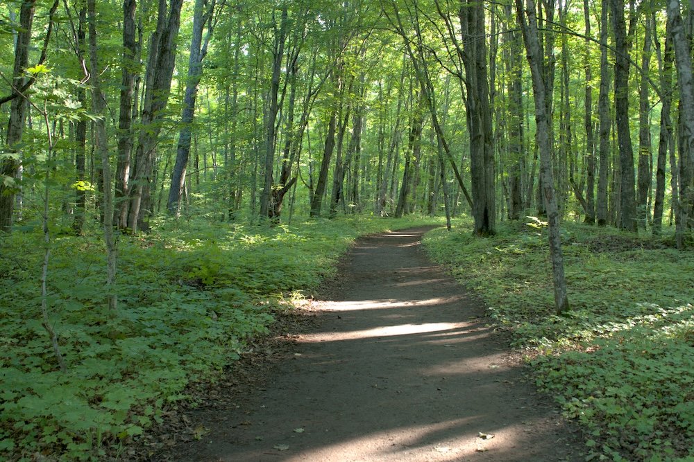
You’ll have about a 1.25 mile hike through the forest to reach Mosquito Falls. You’ll have a fair bit of up and down, though there’s nothing too strenuous. Just keep an eye out for tree roots and mud. This section of trail had the most uneven terrain and I felt like I had to be more careful here (though I tripped twice on the trail and neither fall was in this area). It’s not bad but it’s just something to be aware of, especially if you end up hiking counterclockwise and this section comes after 10 miles of hiking.
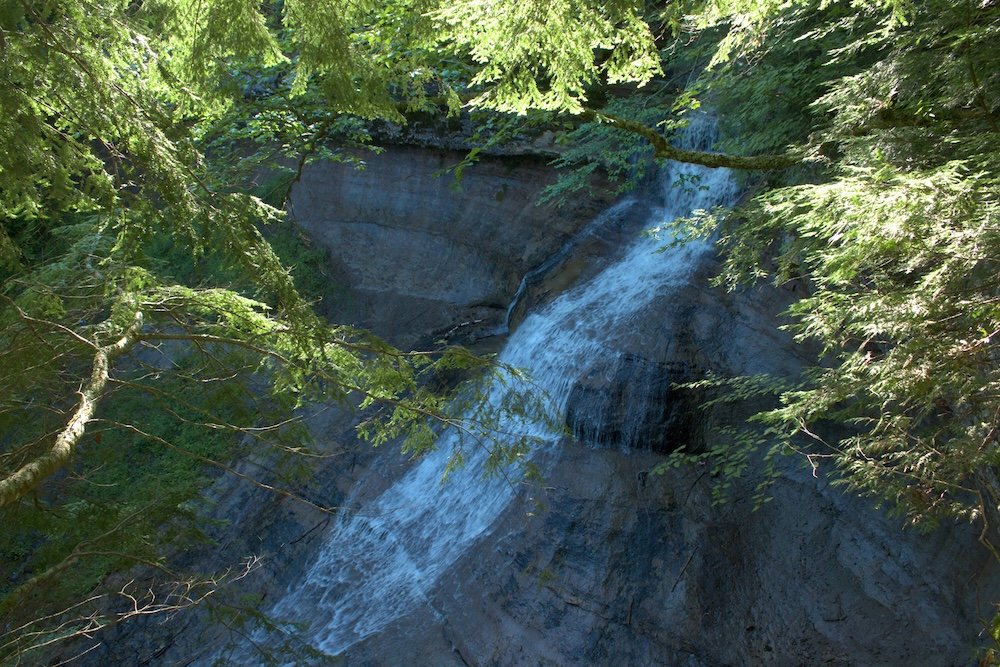
Mosquito Falls is a nice waterfall, but I think that Chapel Falls, which you’ll pass later, is better. Still, you hike right past the waterfall, so take a moment to stop and appreciate it.
Mosquito Falls to Mosquito Beach
I had some issues in this section and I lost the trail for a bit. Maybe it’s more straightforward if you hike clockwise, but getting from Mosquito Beach to Mosquito Falls (in a counterclockwise direction) could have had better signage. Note that this was the only part of the trail that felt like this. Everywhere else, it was super clear where I needed to go.
It’s about another 1.5 miles from Mosquito Falls to Mosquito Beach and you’ll have a bit of up and downs (though mostly up) as you make your way to the beach. This section is still in the forest, so if you find yourself questioning why I rate this trail so high, just wait. Everything gets so much better after Mosquito Beach.
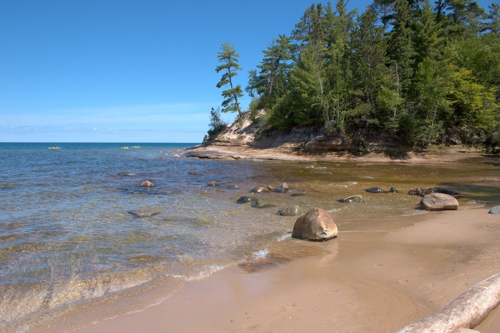
Mosquito Beach offers your first glimpse of Lake Superior and in my opinion, it’s a great place to stop for a short break. Eat a snack, enjoy the views, and get ready for a great rest of the trail.
Mosquito Beach to Chapel Rock
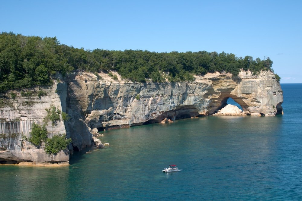
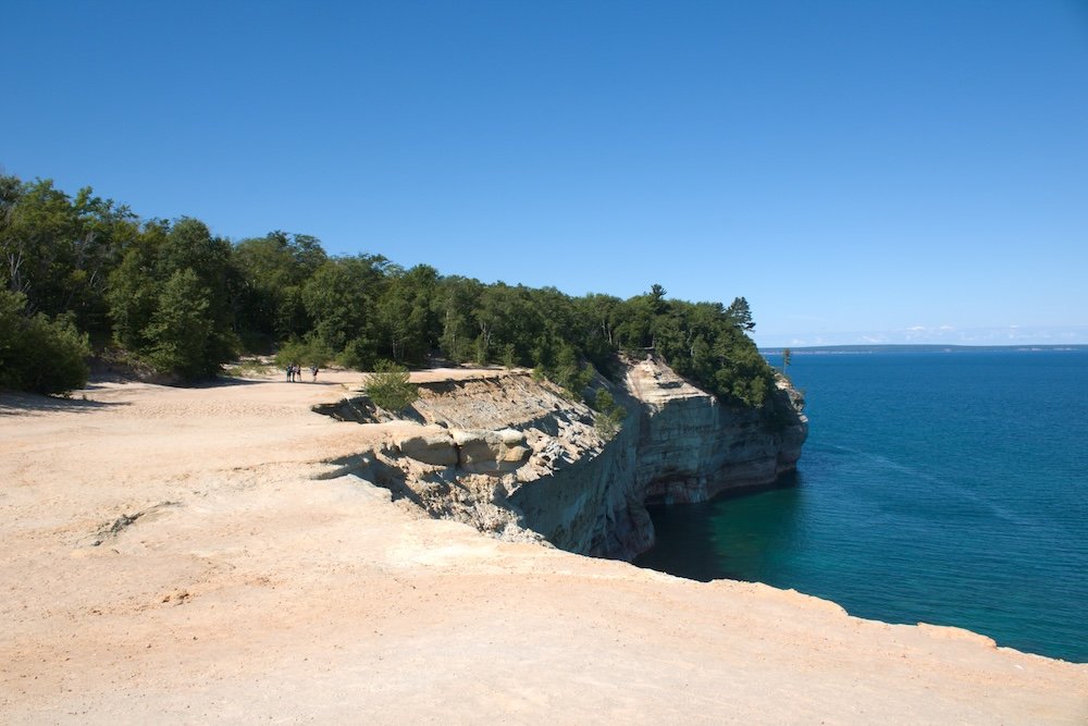
The section from Mosquito Beach to Chapel Rock is my favorite part of Chapel Mosquito Loop and Pictured Rocks National Lakeshore. This section stretches over five miles and follows the cliffs along Lake Superior. Throughout the trek you’ll constantly find yourself poking out to views of Lake Superior. My favorite was Grand Portal which is a large, open and exposed area right along the cliff edge (though there’s plenty of room so you’re not right on the edge). This also makes a great stop for a break.
You’ll climb up from Mosquito Beach, have a mostly flat section and then descend back down just before you reach Chapel Beach and the adjacent Chapel Rock.
If you follow along on your phone, you’ll notice that on Google Maps (if you have maps downloaded or by some miracle get a dash of service) that you’re passing numerous viewpoints. Many of the viewpoints don’t mean much from on top of the cliffs. They are great markers to show where you are on a map, but these markers are best viewed from the water on a kayaking tour or on a Pictured Rocks Cruise.
Overall, my advice for this section of trail is to savor it. It’s scenic, not too difficult, and a joy to hike.
Chapel Rock to Chapel Falls
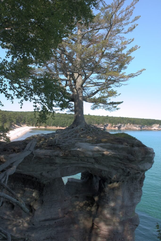
Just beyond Chapel Beach, you’ll find Chapel Rock, which is the most photographed spot in Pictured Rocks National Lakeshore. This is a massive tree that has been growing on a rock. The roots extend past the rock and connect the tree to the mainland. Don’t get me wrong, it’s cool, but I think it can be easier to appreciate from the water. Regardless, enjoy the view, you’ve earned it.
You’ll have to hike another two miles from Chapel Rock, before you reach Chapel Falls. You’ll have one big climb but then you’re done and the trail really evens out after this point (though it’s not completely flat). After you depart Chapel Rock, you’ll be back in the forest and for me, this was less exciting that the section along the cliffs of Lake Superior, but you’ll be working your way back to the trailhead.
Chapel Falls to the Trailhead
Chapel Falls is the last big stop on the Chapel Mosquito Loop. It’s a great waterfall and in my opinion, it’s more impressive than Mosquito Falls. Enjoy the views before the remaining 1.6 miles back to the trailhead.
While the trail from the trailhead to Mosquito Falls felt covered in roots and mud, I didn’t feel the same about the section from Chapel Falls to the Trailhead. I felt that I moved faster on this section, but maybe that was just because I had more energy when I started hiking in the morning.
After over eleven miles of hiking, you’ll finally reach the trailhead and will have completed the Chapel Mosquito Loop.
Trail Stats
I logged 11.25 miles and 860 feet of elevation gain. I completed this trail in just over 5 hours (5 hours and 5 minutes to be exact) and that includes plenty of time to stop for pictures and a quick snack break at Mosquito Beach.
General Tips for the Chapel Mosquito Loop
Now that I’ve given an overview of the trail, let’s talk about some general tips.
Get to the Trailhead Early
I arrived around 7:30 am and had no problem finding a parking spot. There were still plenty of spaces available. When I finished the trail five hours later, every spot was filled. Cars lined the road for a solid half mile past the parking lot. And the only thing to do here is hike this trail (though there are ways to shorten the 11 mile loop), so you’ll be sharing the trail with that many more people. If you want a more relaxed experience, hike early in the day.
Give Yourself More Time Than You Think You’ll Need
I’m not sure where the time went on this trail, but it definitely took me longer than I was expecting. Based on reviews on AllTrails, I wasn’t the only one. Maybe I stopped for too many photos, but I expected to finish the Chapel Mosquito Loop in just about 4 to 4 1/2 hours. As I said above, it took me just over five hours. Make sure to give yourself adequate time because you really do not want to rush that section along the cliffs.
Hike the Chapel Mosquito Loop Before Taking a Cruise
If you also plan to take a Pictured Rocks Cruise (and I recommend that you do), hike this trail before you take your cruise. From the boat, you’ll see Mosquito Beach and then you’ll cruise past all of those points of interest that you couldn’t see from the trail above. What’s really cool though is that this cruise puts your hike into perspective. You’ll cruise from Mosquito Beach to Chapel Rock and it helps to give a huge sense of accomplishment when you see how far you hiked.
Entrance Fees for Pictured Rocks National Lakeshore
While you won’t pass any check points or entrance stations, you still need to pay a fee to visit Pictured Rocks National Lakeshore. A pass that is good for 1-7 days can be purchased online or from the Visitor Center for $25. Passes like the America the Beautiful pass are also accepted.
Display your pass on your dashboard.
Cell Phone Service in the Upper Peninsula
Michigan’s Upper Peninsula is sparsely populated. What that means is service can be very spotty throughout not just Pictured Rocks National Lakeshore, but the entire peninsula. Therefore, it’s important to plan ahead and not just rely on your phone.
Download Google Maps (or your preferred map service) for offline use. This means that even if you don’t have service (which is very likely near Pictured Rocks National Lakeshore), you can still navigate to where you need to go. I also recommend stopping at the visitor center to pick up a map. I do this regardless but there were a few times where my phone acted up and didn’t want to navigate (even though I had maps downloaded on my phone).
Where to Stay at Pictured Rocks National Lakeshore
Munising is the closest town to Pictured Rocks National Lakeshore and has several hotel options. You’ll also find restaurants and plenty of souvenir shops, just like any tourist town.
My hotel was just outside of Munising in the town of Wetmore.
When to Visit Pictured Rocks National Lakeshore
Technically, Pictured Rocks National Lakeshore can be visited all year round. However, you’re in the north of the country and along the largest freshwater lake in the United States. It gets cold and very snowy, so I’d think twice about visiting in winter.
Peak travel time is the summer months. This gives you the best weather as well as the most options. Pictured Rocks Cruises (another highlight of this area) only run for a few months out of the year, typically from May through October. However, I personally would recommend looking at the summer months, so you can try to guarantee the best weather.
Final Thoughts
The Chapel Mosquito Loop is an excellent trail and my favorite at Pictured Rocks National Lakeshore. This trail covers waterfalls, dramatic cliffs, Lake Superior, and even more. It’s a fantastic trail for anyone in the area.
Continue Your Adventure
Pictured Rocks National Lakeshore: Don’t miss out on a scenic cruise to catch the most iconic views of this region. For more hiking, check out my list of top hikes at Pictured Rocks. Plan your trip with my one day itinerary for Pictured Rocks.
Michigan: In the northern part of Michigan’s Lower Peninsula, you’ll find Sleeping Bear Dunes National Lakeshore. Off the coast in Lake Huron, you’ll find the car free island of Mackinac Island. Loop the highlights of Michigan together in my five day itinerary. Learn even more in my Michigan Travel Guide.
Apostle Islands National Lakeshore: Located in Wisconsin on the shores of Lake Superior, the Apostle Islands are another great option on Lake Superior. Take a scenic cruise or get out and take a hike.
More in the Midwest: If you head to Illinois, you can visit the best of Chicago. Slightly east of Chicago is Indiana Dunes National Park. Is Iowa, don’t miss the caves at Maquoketa Caves State Park.