
Michigan is full of natural beauty. From dramatic cliffs to towering sand dunes to car free islands, this five day Michigan itinerary covers a lot of variety. You’ll work your way from Pictured Rocks National Lakeshore in Michigan’s Upper Peninsula, down and across the Mackinac Bridge, and along Lake Michigan until you reach Traverse City and Sleeping Bear Dunes National Lakeshore.
5 Day Michigan Itinerary
Normally I start my itineraries with information about where to fly into and how to get around. This Michigan itinerary is more complex, so I’ll cover more about airports later in this itinerary. As far as getting around, you’ll need to have your own vehicle as many parts of this itinerary are very rural.
Day 1 – Arrive in Michigan
This Michigan itinerary starts at Pictured Rocks National Lakeshore which is near the town of Munising in Michigan’s Upper Peninsula. There is no airport in Munising (the closest airport is a very small regional airport in Marquette). So for today, your goal is to make it to Munising from wherever you are coming from.
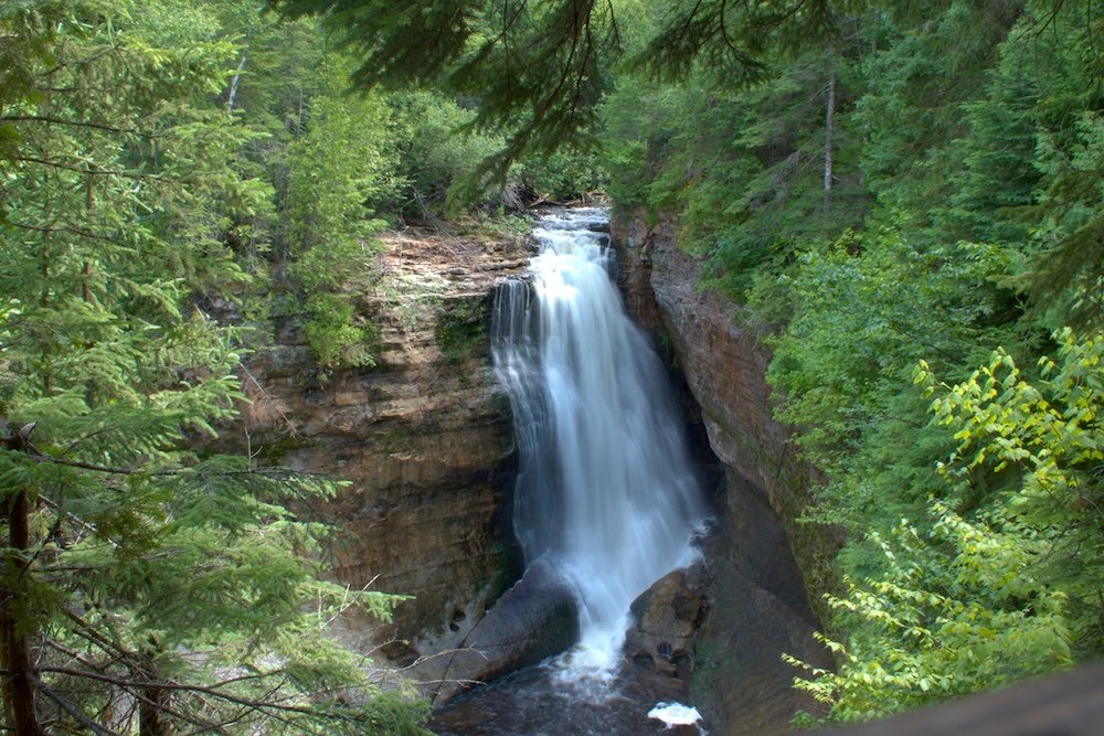
If you have time later in the evening, consider spending some time in the town of Munising. It is a small tourist town with some shops, restaurants, and nice views of Lake Superior. Near the town is Wagner Falls, a short 5 minute walk to a waterfall. You’ll also be nearby the Pictured Rocks National Lakeshore Visitor Center, so stop in here to grab a map. Cell phone service is very spotty in the Upper Peninsula so it’s good to have a physical map for reference.
Spend the night in Munising and get ready for the real start of your trip.
Day 2 – Pictured Rocks National Lakeshore
Today you’ll have one full day at Pictured Rocks National Lakeshore, so you need to make it count. There’s a few ways you could spend your day and it all depends on how much hiking you want to do.
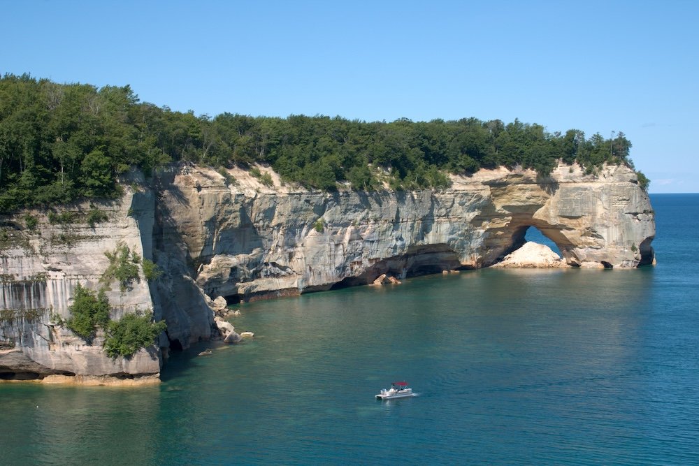
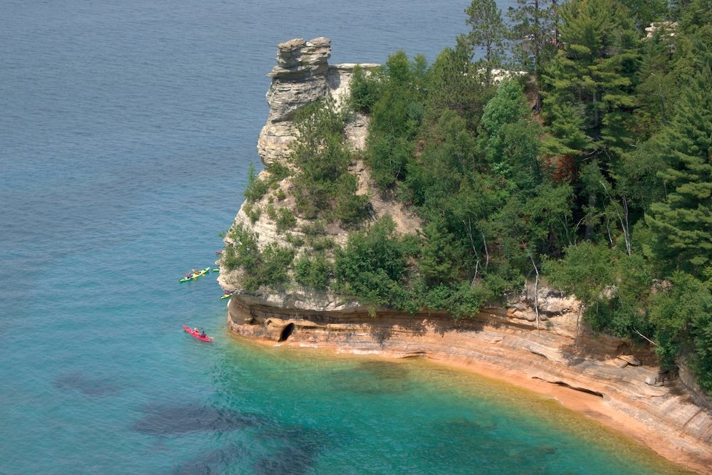
For people who love hiking, start your day with the Chapel Mosquito Loop. This 11 mile trail takes you through the forest, past waterfalls, and out along the dramatic cliffs of Pictured Rocks National Lakeshore. It’s one of my favorite day hikes and I highly recommend it if you’re able. After, swing past Miners Falls for a short 1.2 mile trail before visiting Miners Castle Rock, a short five to ten minute walk to some nice viewpoints. Finish your day with a cruise along Lake Superior and the famous Pictured Rocks.
For those who don’t want to hike 12+ miles in one day, you still have options including shorter hiking trails. Visit Miners Falls in the morning for a 1.2 mile hike to the waterfall. By getting an early start, you’ll hopefully beat some of the crowds. Stop back in Musing for a cruise along Pictured Rocks. This cruise is sure to be a highlight of your day.
Now let’s start heading east. Visit Miners Castle Rocks for one more great view of the cliffs of Pictured Rocks. You can stop by Au Sable Lighthouse (1.5 mile walk each way to the lighthouse) to take a ranger led tour and finish your day at Sable Falls and Sable Dunes (about 1.25 miles of hiking).
For sleeping tonight, I think it depends which activities you planned and how much energy you think you’ll have.
For those who hiked 12+ miles and finished your evening with a cruise in Munising, consider spending the night in Munising. You’ll have more driving tomorrow, but I think the hike of the Chapel Mosquito Loop is better than anything on tomorrow’s agenda.
For those who chose to skip the big hike and explore the eastern part of Pictured Rocks National Lakeshore, continue driving south until you reach St. Ignace. This is the town just before the Mackinac Bridge and provides a gateway to Mackinac Island (though you could cross the bridge and stay in Mackinaw City too).
Day 3 – Mackinac Island
If you spent the night in St. Ignace or Mackinaw City, you get to have a little bit of a lie in this morning. If you stayed in Munising, try to get up early. You’ll have a two hour drive before you reach St. Igance.
Today we’re taking a day trip to Mackinac Island. This is a car free island in Lake Huron that’s famous for its fudge. While you could stay overnight on the island, many people (myself included) choose to take a day trip to the island. Ferries connect both St. Ignace and Mackinaw City with Mackinac Island on a frequent basis. That said, I recommend trying to get an early start and doing a little bit of research.
Obviously, getting an early start means less crowds. Particularly in summer, crowds can feel overwhelming and the earlier you start, the more likely it is that you’ll get to enjoy some peace on the island before all of the other day trippers come. That said, don’t take too early of a ferry. You’ll want to time your arrival with the opening times of bike rentals, coffee shops, and stores.
Also, I highly recommend looking at the schedule for your ferry to see if there is a special bridge ferry. I used Shepler’s Ferry and they offered a “Mighty Mack” service a few times a day. This service cost the same as a regular ferry, but included a 12 minute detour where we went out and under the Mackinac Bridge. There are plenty of viewing platforms from the mainland, but nothing is quite like the view of the bridge from the water.
So what do you do on Mackinac Island? I recommend renting a bike and circling the island. This is the only highway in the United States where cars are banned. Try to do this early because the road really fills up with bikers later in the day. You can also visit the shops and tour Fort Mackinac. And of course, you have to sample the fudge. There are several fudge shops on the island (and many have branches on the mainland as well), so don’t forget to pick up some fudge before you leave.
I found that I was able to see everything I wanted on Mackinac Island in just a few hours. So, when you’re ready, take the ferry back to the mainland and continue driving to Traverse City. From St. Ignace and Mackinaw City, it’s another two hours to Traverse City.
Note that you cannot bring your car to Mackinac Island, so you’ll need to find some place to park it while you visit the island. Your ferry service should have information about parking in both St. Ignace and Mackinaw City.

Day 4 – Sleeping Bear Dunes National Lakeshore
Day 2 was all about the cliffs of Lake Superior. Day 3 saw you out on an island in Lake Huron. Day 4 is all about the sand dunes of Lake Michigan. So by the end of this itinerary, you’ll have spent time on 3 of the 5 Great Lakes.
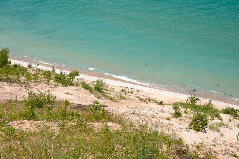
Yes, Sleeping Bear Dunes is famous for the sand dunes along the beach, and we will see those today, but there’s also several great hikes. Today, I recommend trying to cover as many hikes as possible.
Start your day at the Treat Farms Trail. This 2.25 mile trail takes you through the forest and out to Lake Michigan. It’s up to you if you want to hike on the dunes (making the hike moderate instead of easy) or turn around and come back the way you came (making this a much easier hike).
Nearby is the Empire Bluff Trail. The views are nice, but this trail can get busy. In fact, it was the busiest trail I hiked during my time at Sleeping Bear Dunes. The trail is 1.7 miles and takes you out to Lake Michigan. If you’re concerned about the amount of hiking I’m placing on this itinerary and don’t think you’ll be up to it, pick either the Treat Farms trail or the Empire Bluff Trail (and personally, I think I’d pick the Treat Farms Trail).
One hike that you shouldn’t skip is Sleeping Bear Point Loop. This was my favorite hike of the day. You’ll spend 2.5 miles hiking up and down the sand dunes. But it’s not the super steep sand dunes that you may have seen in pictures. Sleeping Bear Point does involve some climbing, but it’s so much more manageable than many of the other steep dunes at Sleeping Bear Dunes. The views are great, the crowds are relatively light, and the trail was a delight to hike.
Dune Climb is perhaps the most popular area at Sleeping Bear Dunes. Rather than running down to the beach and then strenuously climbing back up, you can climb up first and then run down. So if you are climbing and feel like it’s too much, just turn around and run back the way you came. It’s a fun experience and I recommend stopping here. Note that you can hike all the way to Lake Michigan from Dune Climb, but I don’t recommend it for this itinerary. The hike is very strenuous and I think there are better places to enjoy hiking at the park.
The Alligator Hill Trail takes you out to a few of Lake Michigan and while the views are nice, I don’t think they were my favorite of the day. Still, this is a 2.8 mile trail that is popular, so I want to make you aware of it. Instead, for those feeling like it’s too much, I much preferred the views at Pyramid Point. This is a 1.25 mile trail that not only takes you out to a view of Lake Michigan, but you’ll also get to see the super steep sand dunes up close (though you don’t have to climb them as part of this trail).
For non-hiking activities, look at the Pierce-Stocking Scenic Drive. As far as scenic drives go, it’s not my favorite (though that’s probably because the views look so similar to what I have at home). However, there are some good stops along the way. The most popular (and my favorite) is stop #9 which has those famous steep sand dunes. You can run down to the beach if you want, but keep in mind, you’ll have to climb all the way back to the top after.
When you’re done at Sleeping Bear Dunes, head back to Traverse City to relax for the night.

Day 5 – Depart Michigan
This 5 day Michigan itinerary is over. While it may have been difficult to figure out flights to Pictured Rocks National Lakeshore, Traverse City offers flights to many more destinations. It’s still a small airport, but compared to many of the other airports in northern Michigan, Traverse City has loads of flight options.
With More Time
With more time you have options. You could extend your trip to accommodate the not-so-great airport situation (more on this later). If you have enough time to add an extra day for exploring, you have options too.
First, you could spend an extra day at Pictured Rocks National Lakeshore. You’ll have some time to do extra hikes in the park, visit the Sable Lighthouse, or take a kayaking tour. If I had a choice, this is where I’d add my time.
At Sleeping Bear Dunes, I think this itinerary covers a lot of the highlights, but Traverse City is a tourist city even without access to the dunes. Check the city calendar for any number of festivals or enjoy what you find in the city along the shores of Lake Michigan.
With Less Time
Unfortunately if you have less time, you’re going to really struggle with this itinerary. I don’t think it’s possible to do this itinerary with less time. So, if you have less than five days, you’ll have to cut a significant portion of this itinerary and only focus on two of the three major destinations. Either stick to the Upper Peninsula and visit Pictured Rocks and Mackinac Island or stick to the Lower Peninsula for Sleeping Bear Dunes and Mackinac Island (though you could just focus on Sleeping Bear Dunes and Traverse City).
Which Airport Should You Use
This is the hardest question to answer. Traverse City, near Sleeping Bear Dunes National Lakeshore, has reasonable connections to the rest of the United States. It’s not a major airport, but compared to everything else nearby, this is the best airport for most travelers. The problem, of course, is that you’re far away from Pictured Rocks National Lakeshore. So your best option may be to book a return trip to Traverse City and make sure to budget extra time into your trip to drive round trip to Pictured Rocks National Lakeshore.
There are four very small airports in northern Michigan. Marquette (MQT) is the closest to Pictured Rocks National Lakeshore. Sault Ste. Marie (CIU) sits near the Canadian border and is two hours from Pictured Rocks. Next, you have Pellston (PLN) which is in the very north of Michigan’s Lower Peninsula. All three of these airports connect to Minneapolis (MSP), Chicago’s O’Hare (ORD), and Detroit (DTW). However, they only offer one flight to each of these destinations per day. The other airport is Escanaba (ESC) which is about two hours south of Pictured Rocks National Lakeshore but only connects to Minneapolis and Detroit with very limited flights.
Therefore, it might be best to consider adding this trip to an even larger trip. Here’s some of my suggestions.
- Continue heading west from Pictured Rocks National Lakeshore and visit the Apostle Islands National Lakeshore in northern Wisconsin. From there, you’re just an hour and a half drive from Duluth, MN (DUL) which has many more connections.
- Reserve this itinerary and head south after Pictured Rocks National Lakeshore. Stop in Escanaba, MI and continue heading south toward Wisconsin. Fly home from Green Bay (GRB) or Appleton (ATW). Admittedly neither are bustling airports and you probably won’t get a direct flight, but flights to major airports are much more frequent than those airports in Upper Michigan.
- Turn this into an even bigger trip and do then entire Lake Michigan Circle Tour. You’ll need at minimum two weeks for this (assuming you want to make some stops along the way), but then you have a load of choices for flights. Start your adventure in Chicago (ORD or MDW) as this airport will have the most connections of the region.
But Kristen, what did you do on your trip? Well, I didn’t use any airport. I live in Wisconsin, so I was able to drive and I didn’t have to worry about organizing flights. Since not everyone lives in Wisconsin, what I did is not reasonable to expect of everyone.
Cell Phone Service in the Upper Peninsula
Michigan’s Upper Peninsula is sparsely populated. What that means is service can be very spotty throughout not just Pictured Rocks National Lakeshore, but the entire peninsula. Therefore, it’s important to plan ahead and not just rely on your phone.
Download Google Maps (or your preferred map service) for offline use. This means that even if you don’t have service (which is very likely near Pictured Rocks National Lakeshore), you can still navigate to where you need to go. I also recommend stopping at the visitor center to pick up a map. I do this regardless but there were a few times where my phone acted up and didn’t want to navigate (even though I had maps downloaded on my phone).
When to Visit Michigan
Technically, this Michigan itinerary could be done all year round. However, you’re in the north of the country and along the largest freshwater lake in the United States. It gets cold and very snowy, so I’d think twice about visiting in winter.
Peak travel time is the summer months. This gives you the best weather as well as the most options, so personally, I would look at visiting in the summer months.
Final Thoughts
While Michigan may not have the same allure as states out west, there’s still a lot of beauty to be found in this region. Enjoy the colorful cliffs and the dramatic sand dunes as you explore northern Michigan.
Continue Your Adventure
Michigan: Pictured Rocks National Lakeshore is located in Michigan’s Upper Peninsula. Whether you head out on a great hike or take a scenic cruise, you’re sure to see some incredible beauty. In Lake Huron, you’ll find the car free Mackinac Island. On Lake Michigan, enjoy Sleeping Bear Dunes National Lakeshore. Learn how to spend one day at Sleeping Bear Dunes National Lakeshore.
Wisconsin: I have to give a plug for my home state of Wisconsin. If you like sand dunes and views of Lake Michigan, you’re sure to enjoy Kohler Andrae State Park. For more cliffs, head to northern Wisconsin for the Apostle Islands National Lakeshore.
More in the Midwest: If you head to Illinois, you can visit the best of Chicago. Slightly east of Chicago is Indiana Dunes National Park. Is Iowa, don’t miss the caves at Maquoketa Caves State Park.