
Pictured Rocks National Lakeshore in Michigan’s Upper Peninsula is famous for dramatic, colored cliffs that tower over Lake Superior. While you can absolutely experience these cliffs from the water (and you should), this post will instead be focused on the best hikes you can find in this area. From waterfalls to sand dunes to views of Lake Superior and dramatic cliffs, there’s a hike for everyone on this list.
In this guide, I’ll cover all of the best Pictured Rocks hikes so you can plan the trip that works the best for you.
Top 10 Pictured Rocks Hikes
This is not a list of every single hike that you can do at Pictured Rocks National Lakeshore. Rather, it’s a list of what I think are really great hikes for first visitors to consider.
This list is in no particular order.
Chapel Mosquito Loop
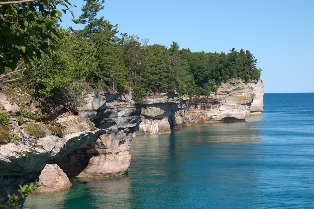
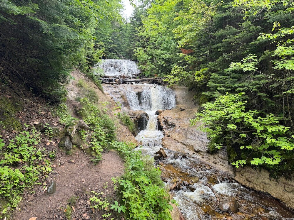
I know I said that this list is in no particular order, but I’m starting with my favorite hike at Pictured Rocks National Lakeshore. It’s also the longest hike on this list coming in at nearly 11.25 miles. It’s a fantastic loop that takes you Chapel Rock then along the magnificent cliffs of Lake Superior up to Mosquito Beach. From the beach, you’ll head back into the forest as see Mosquito Falls before reaching the trailhead and completing your loop.
This trail has a little bit of everything. There’s waterfalls, beaches, and of course the cliffs. For much of the trail, you’ll be hiking along Lake Superior and will get fantastic, ever changing views. Without a doubt, my favorite stop was Grand Portal which is a wide open cliff face and some of my favorite views of Lake Superior.
The Chapel Mosquito Loop is a long trail and will take a good chunk of your day to complete. But it’s my favorite because of the variety and beauty found on this trail.
I logged 11.25 miles and 860 feet of elevation gain. This trail took me about five hours, which includes stops for pictures and a short stop at Mosquito Beach to eat a quick snack. I recommend giving yourself more time than you think you’ll need for this trail because for some reason time moves differently and many hikers find that they take longer than they were expecting (I thought I’d be done in just over four hours and was off by an entire hour).
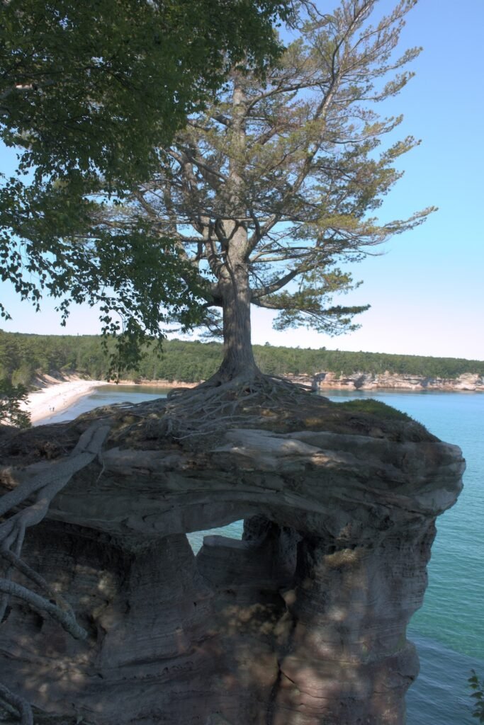
Chapel Rock Loop
If you’re not feeling up to the entire 11.25 mile Chapel Mosquito Loop, you can do a smaller loop that just goes as far as Chapel Rock. On the way you’ll pass Chapel Falls and of course you’ll reach Chapel Rock, which is one of the most iconic views at Pictured Rocks National Lakeshore. Just a smidge beyond that is Chapel Beach. From Chapel Rock and Chapel Beach, you’ll get a few good views of the cliffs before you head back to the forest and to the trailhead.
Obviously I didn’t hike this trail in full because I did the Chapel Mosquito Loop. The NPS estimates this to be about 6.2 miles.
Mosquito Beach Loop
Like the Chapel Rock Loop I mentioned above, there’s a loop that just focuses on Mosquito Beach and Mosquito Falls. While you could just hike out and back to Mosquito Beach, I would recommend detouring for Mosquito Falls, just to get a little variety in scenery (and to visit a waterfall).
If you hike out and back to Mosquito Beach, you should estimate about 3.9 miles. To add in Mosquito Falls, estimate 4.5 miles round trip.
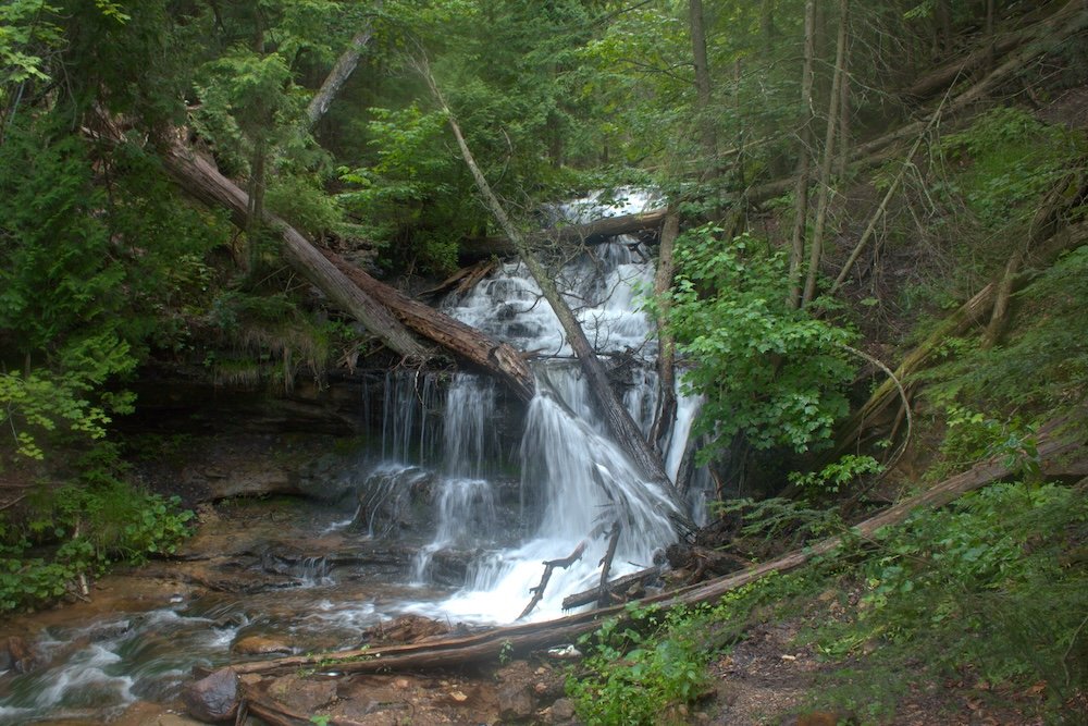
Miners Falls
Sometimes the trail is the destination (like with the Chapel Mosquito Loop). Other times, the trail is just a means to get to your destination. The trail to Miners Falls is one of those where the destination is great, but the trail is nothing too special. I think this is especially true because the trail is busy and I was constantly passing hikers in each direction. If you’re looking for tranquility on a trail, you will really need to look elsewhere.
Still, if you want an easy hike to a waterfall, Miners Falls is a good hike to consider.
I logged 1.2 miles and 150 feet of elevation gain. This trail took me 25 minutes to complete.
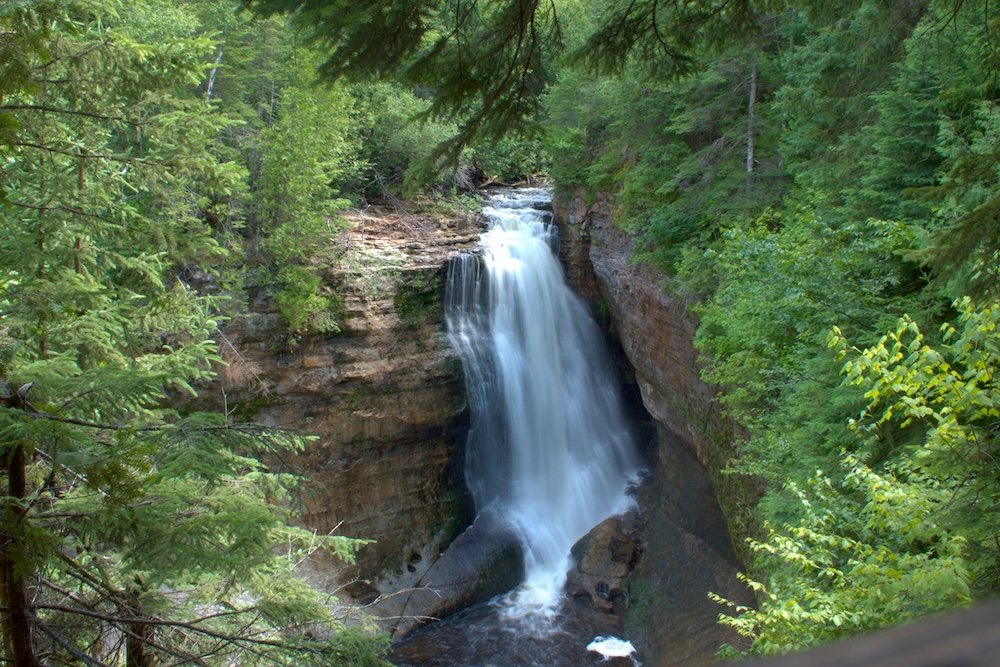
Sable Dunes & Sable Falls
From the trailhead, you’ll have to make a choice. Do you head to the right and visit Sable Falls or do you head left and visit the sand dunes? I vote both because the two landscapes feel very different.
Sable Falls is just a short distance from the trailhead and takes you to a waterfall in the forest. In my opinion, this appeared to be the more popular of the two destinations on this trailhead, but the falls are nice so this makes sense. It’s 168 steps down (and then back up) to reach the main viewing platform.
For different scenery, head to the left. After a short walk through the woods, you’ll reach the sand dunes near Lake Superior. While not as dramatic as what you will find at Sleeping Bear Dunes National Lakeshore or even the Log Slide Overlook here at Pictured Rocks (covered later), it’s still a nice bit of scenery. Admittedly, I was here on a day with not great weather, but while there were other visitors to Sable Falls, I only passed one other pair of hikers on my visit to Sable Dunes.
I logged 1.25 miles and 150 feet of elevation gain. I started the trail and went to Sable Dunes first before looping back to visit Sable Falls. It took me about 30 minutes to visiting both stops.
Wagner Falls
Wagner Falls is technically outside Pictured Rocks National Lakeshore, but it’s so close that I’m including it on this list. It’s also the shortest trail on this list and it’s so short I barely consider it a trail. From the parking lot, you have a very short walk and you’ll reach a viewing platform for Wagner Falls. The waterfall is nice and because it’s so quick, I think it’s worth a stop.
I logged 0.25 miles and 10 feet of elevation gain. It took about 5 minutes.
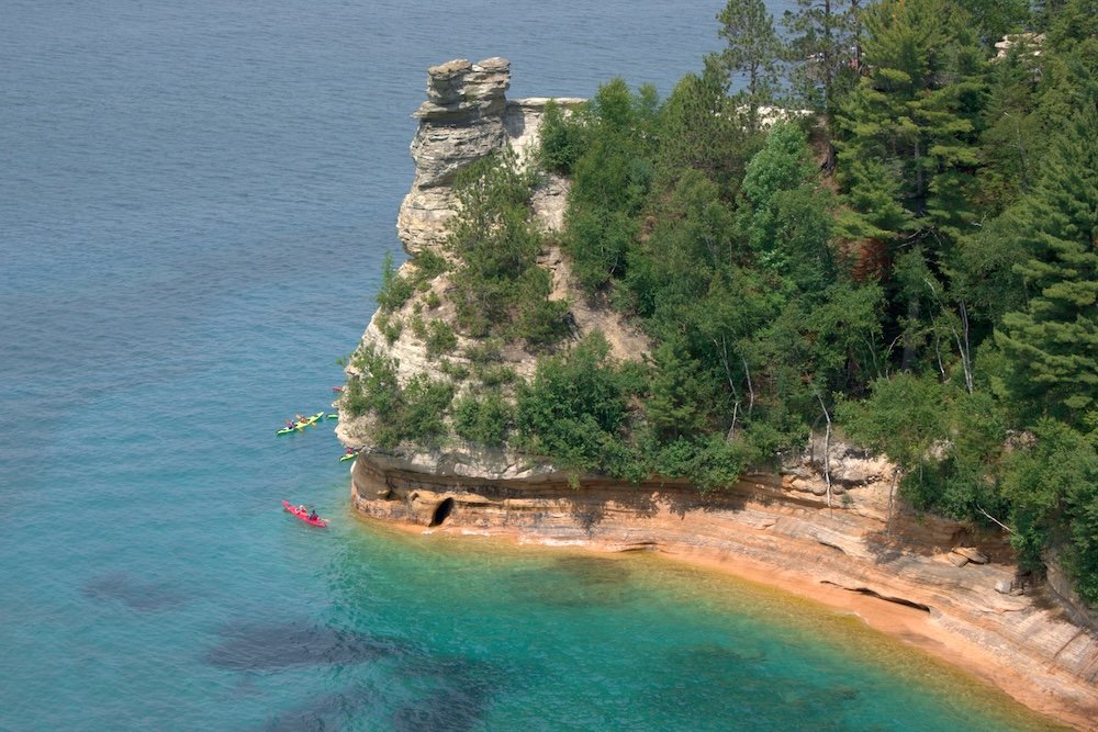
Miners Castle Rock Trail
The Miners Castle Trail isn’t a hike in the traditional sense. You won’t be hiking through the forest and most of your time will be spent on a paved path. However, it’s absolutely still worth a stop. From here, you’ll find two different viewing platforms for the cliffs of Pictured Rocks. The Upper Overlook is closer to the parking lot and it’s a pretty flat walk out here. The Lower Overlook isn’t much further, but you will have to do some stairs to reach this overlook.
Since you’re here, I’d recommend stopping at both viewpoints, but I can say that I liked the Lower Overlook better because it felt like I was so much closer to the cliffs and Miners Castle Rock, which is what these viewpoints are named after.
I logged 0.45 miles and 80 feet of elevation gain. This trail took me ten minutes to reach both viewpoints.
Munising Falls
Coming in at about 0.3 miles round trip, the Munising Falls Trail starts by the Munising Visitor Center and takes you out to a viewing platform for Munising Falls. While the trail is short, you will walk up and down stairs as you reach the viewing platform of the 50 foot waterfall.
This is a trail I didn’t get a chance to hike as it was closed on my visit. It’s always a good idea to check the trail status for any trail prior to starting your trip, so hopefully this trail will be open by the time you visit Pictured Rocks National Lakeshore.
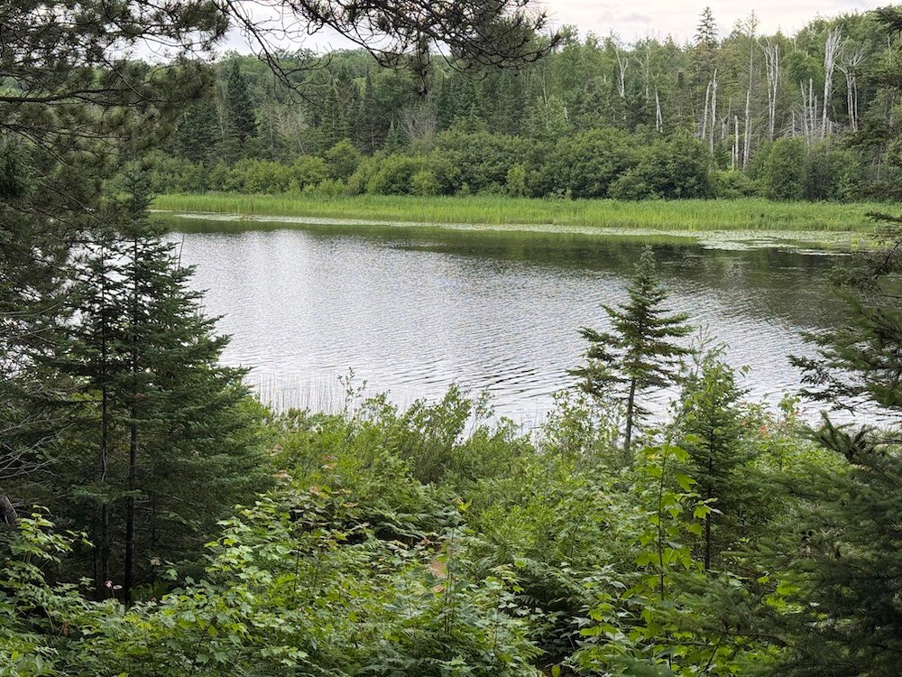
Beaver Lake
To reach Beaver Lake, you’ll need to walk just over a mile from the trailhead. You’ll be walking through the woods and fundamentally, I don’t think it’s much different from the other woodland hikes on this list. That said, there is a cool, small cave that you’ll pass on your way.
Keep an eye out for a fork in the trail. Heading straight will take you out to Lake Superior, while heading right will take you out to Beaver Lake. Once you reach Beaver Lake, you can hike a circular loop around the entire lake. I had plans to do this, but was racing the rain and had to cut my hiking short. Unfortunately the entire loop around Beaver Lake had to get cut.
I did not hike around Beaver Lake, instead choosing to hike out to Lake Superior from the same trailhead. If you want to circle Beaver Lake, you’re looking at a 5.5 mile hike. This estimate includes the loop around the lake and the time spent hiking to reach the lake from the trailhead.
Beaver Lake Trailhead to Lake Superior
If you don’t want to go to Beaver Lake, you can continue heading straight on the trail and you’ll eventually reach Lake Superior. From here, you have a relatively secluded beach as the only way to get here is to hike. There is a campground nearby though, so you won’t be completely secluded.
But I visited early in the morning and the trail was calm and peaceful and I enjoyed my stroll on Lake Superior. While you could turn around as soon as you reach the lake, head west for about a half mile and you’ll find a small cove.
I logged 3.5 miles and 230 feet of elevation gain. This includes about 0.5 miles of walking on the beach to reach a small cove near the Coves Campsite. This took me about one hour and ten minutes.
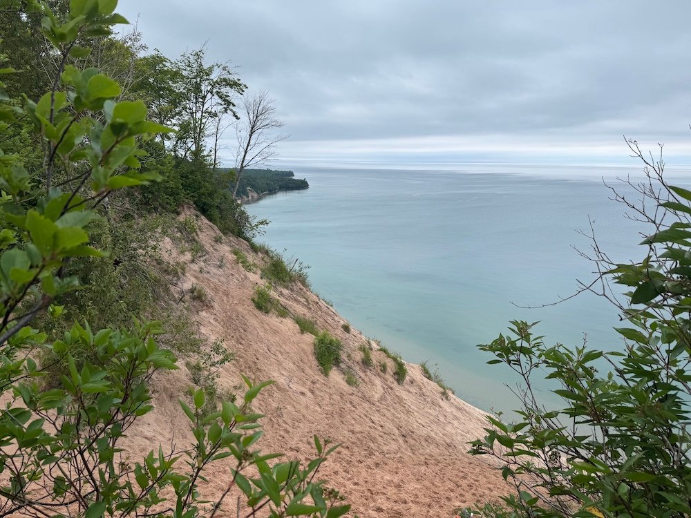
Log Slide Overlook
The Log Slide Overlook is another trail that is so short that it barely counts as a hike, but I’m including it anyway, because I do think it’s worth a stop. This part of Pictured Rocks National Lakeshore was known for its logging, so as you walk out to the overlook, you’ll pass some historic logging equipment and informational signs.
The overlook is at a steep sand dune leading down to Lake Superior. Honestly, it looks more like something you’d find at Sleeping Bear Dunes National Lakeshore, but it’s on Lake Superior, not Lake Michigan. The overlook is nice, but if you have to share it with a whole group of people (I happened to arrive just as a tour bus unloaded), it’s not as relaxing.
I logged 0.4 miles and 7 feet of elevation gain. It took me 10 minutes. Note that you can walk down the sand dune to the lake, but you’ll have a very strenuous hike back to the top of the dune. Think twice before you run all the way to Lake Superior.
So Which are the Best Pictured Rocks Hikes?
Without a doubt, my favorite hike at Pictured Rocks National Lakeshore was the Chapel Mosquito Loop. If you can only do one hike, I’d highly recommend this one.
Now, I do realize that that hike is the longest on this list and not everyone can, or wants to spend their vacation hiking that much. If you still want to hike in this area, you can do either the Chapel Rock Loop or the Mosquito Loop. Personally I think the Chapel Rock Loop is better. It is longer, but I found that section of trail easier and I think the views from Chapel Rock are more rewarding.
Beyond the Chapel Mosquito Loop area, I’d recommend looking at the Miners Falls Trail or the Sable Dunes and Sable Falls Trail. You can’t go wrong with either one. Miners Falls is closer to Munising, but I liked Sable Dunes and Sable Falls better.
How Long Do You Need at Pictured Rocks National Lakeshore
At a minimum, I recommend giving yourself one full day at Pictured Rocks National Lakeshore. This gives you time to do some hiking and take a scenic cruise. That said, you can’t go wrong with two days here. Two days will just give you a little more time so you can spread things out and make it to some of the less busy areas outside of Munising.
Entrance Fees for Pictured Rocks National Lakeshore
While you won’t pass any check points or entrance stations, you still need to pay a fee to visit Pictured Rocks National Lakeshore. A pass that is good for 1-7 days can be purchased online or from the Visitor Center. Passes like the America the Beautiful pass are also accepted.
Display your pass on your dashboard.
Cell Phone Service in the Upper Peninsula
Michigan’s Upper Peninsula is sparsely populated. What that means is service can be very spotty throughout not just Pictured Rocks National Lakeshore, but the entire peninsula. Therefore, it’s important to plan ahead and not just rely on your phone.
Download Google Maps (or your preferred map service) for offline use. This means that even if you don’t have service (which is very likely near Pictured Rocks National Lakeshore), you can still navigate to where you need to go. I also recommend stopping at the visitor center to pick up a map. I do this regardless but there were a few times where my phone acted up and didn’t want to navigate (even though I had maps downloaded on my phone).
Where to Stay at Pictured Rocks National Lakeshore
Munising is the closest town to Pictured Rocks National Lakeshore and has several hotel options. You’ll also find restaurants and plenty of souvenir shops, just like any tourist town.
My hotel was just outside of Munising in the town of Wetmore.
When to Visit Pictured Rocks National Lakeshore
Technically, Pictured Rocks National Lakeshore can be visited all year round. However, you’re in the north of the country and along the largest freshwater lake in the United States. It gets cold and very snowy, so I’d think twice about visiting in winter.
Peak travel time is the summer months. This gives you the best weather as well as the most options. Cruises at Pictured Rocks (another highlight of this area) only run for a few months out of the year, typically from May through October. However, I personally would recommend looking at the summer months, so you can try to guarantee the best weather.
Final Thoughts
I really enjoyed hiking at Pictured Rocks National Lakeshore. The hikes had just enough variety to keep me enthralled and wanting to keep hiking. Whether you tackle the Chapel Mosquito Loop or any of the shorter Pictured Rocks hikes covered here, you’re sure to have a good time.
Continue Your Adventure
Pictured Rocks National Lakeshore: Don’t miss out on a scenic cruise to catch the most iconic views of this region. For hikers, don’t miss the Chapel Mosquito Loop. Learn how to plan one day at Pictured Rocks.
Michigan: In the northern part of Michigan’s Lower Peninsula, you’ll find Sleeping Bear Dunes National Lakeshore. Off the coast in Lake Huron, you’ll find the car free island of Mackinac Island. Learn more in my Michigan Travel Guide which has tips and itineraries.
Apostle Islands National Lakeshore: Located in Wisconsin on the shores of Lake Superior, the Apostle Islands are another great option on Lake Superior. Take a scenic cruise or get out and take a hike.
More in the Midwest: If you head to Illinois, you can visit the best of Chicago. Slightly east of Chicago is Indiana Dunes National Park. Is Iowa, don’t miss the caves at Maquoketa Caves State Park.